The members of a European Union (EU) funded map data standardization project are eagerly awaiting the planned introduction of Intelligent Speed Assistance (ISA) systems on all new vehicles, with the technology expected to have a huge impact on traffic safety.
 ISA uses a speed sign-recognition video camera and/or GPS-linked speed limit data to advise drivers of the current speed limit and automatically limit the speed of the vehicle as needed. ISA systems do not automatically apply the brakes, but simply limit engine power preventing the vehicle from accelerating past the current speed limit unless overridden. Vehicles with this kind of ISA system factory fitted are already on sale, helped in part by Euro NCAP’s decision to reward extra points for vehicles that include the technology. ISA is expected to reduce collisions by 30% and deaths by 20%, with the additional benefit of helping drivers avoid speeding tickets.
On January 10, the Transport Committee of the European Parliament voted to uphold the Commission’s proposal to introduce ISA on all new cars and trucks, but the final say will rest with the Internal Market and Consumer Protection Committee, which is scheduled to vote on the issue around mid-February. A key factor in the successful widespread introduction of ISA systems will be accurate map data.

TN-ITS GO (Transport Network Intelligent Transport Systems) is a Connecting Europe Facility project that contributes to ISA’s success by deploying standardized advanced exchange and update mechanisms for digital map data. TN-ITS GO is planned to be a key part of the digital infrastructure of 15 European Member States and road operators by 2022. Map data greatly contributes to ISA since safe driving speeds depend not just on legal speed limits, but also on other elements such as road topology and curvature, road and traffic conditions, and are often lower than the legal speed limit. Digital maps are able to reflect legal speeds on sections of the road network where implicit restrictions apply, instead of sign-posted ones.
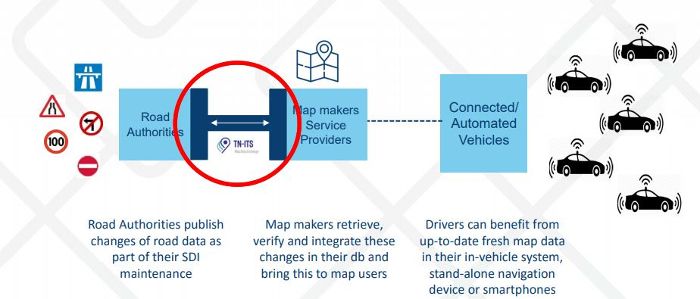
The TN-ITS platform was set up in 2013 to facilitate and foster the pan-European harmonized exchange of modifications in road data between road authorities as trusted and quality data providers, and map makers and other parties as data users. TN-ITS-enabled map data guides the driver in an accurate way toward maintaining the legal speed. TN-ITS services are already active in Finland, Norway and Sweden with a total data update rate of more than one million per year. Road authorities publish changes of road data as part of their Static Digital Infrastructure data maintenance. Map makers retrieve, verify and integrate these changes in their databases and bring this to map users.
“I’m very encouraged by the progress made in the implementation of TN-ITS by the Member States, as well as by the recent release of the CEN Technical Standard,” said Stephen T’Siobbel, president of TN-ITS platform. “ISA is another important service application that can rely on the accurate map data assured by TN-ITS mechanisms. It is another step forward in making roads safer and saving lives.


