Australia’s leader in connected and autonomous vehicle (CAV) communications technology, Cohda Wireless, has released a world-first vehicle positioning system to eliminate the GPS blackspots that exist in urban canyons between high-rise buildings.
Using its expertise in developing collision avoidance systems for mines, Cohda’s new vehicle-based system, V2X-Locate, can identify vehicle position to sub-meter accuracy in environments that degrade GPS accuracy, such as tunnels, underground parking lots and between high-rise buildings. As well as enhancing current connected vehicles, V2X-Locate delivers a critical component for CAVs, which will require uninterrupted positioning data to safely navigate on roads.
Although GPS (global positioning system) navigation systems have revolutionized transport during the past decade, they can suffer from degraded accuracy in locations with compromised sky views, such as the urban canyons formed by high-rise buildings, underground parking lots and tunnels.
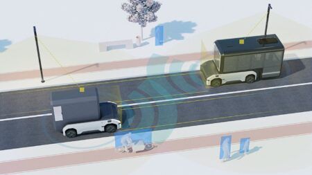
Drawing on its experience in developing collision avoidance systems for underground mines, Cohda has designed V2X-Locate to enable equipped vehicles to identify their location using existing smart city-based V2X (vehicle-to-everything) roadside infrastructure from any standards-based manufacturer.
In typical V2X deployments, vehicles are equipped with onboard units (OBUs), while infrastructure is supported by roadside units (RSU) that generally broadcast their position information, so the location of these RSUs is known to any vehicle within communication range.
V2X Locate uses ranging measurements to these fixed RSUs to enable enhanced positioning accuracy. The ranges from spatially separated RSUs are fed into Cohda’s enhanced V2X Locate positioning engine and its advanced processing capabilities is able to calculate a true line-of-sight path regardless of the existence of multipath signals. Both Cohda’s standard V2X OBUs and RSUs use NXP’s RoadLINK chipset, which supports V2X-Locate’s highly accurate performance by delivering best-in-class multipath channel tracking.
Cohda has already demonstrated the efficacy and accuracy of its V2X-Locate system in a 2017 trial in New York City where it repeatedly demonstrated sub-meter accuracy while driving along Sixth Avenue, which has the tallest buildings in the city. Comparably tested GPS-based systems were as much as tens of meters off course, at times showing cars driving through buildings.
After a pre-release in October last year, Cohda received strong interest in V2X-Locate from both smart cities and Tier 1 automotive manufacturers. To meet that demand, the company has released a V2X-Locate Evaluation Kit, which contains the system and four RSUs that equips prospective customers to trial the technology.
“If you’re in a major downtown area with tall buildings, or in a tunnel or in an underground parking lot, a GPS system can fail, preventing it from delivering accurate results. As well as being inconvenient for current drivers, this is not an option as we enter the era of driverless cars,” explained Cohda’s chief technology officer, Dr Paul Alexander.
“V2X-Locate can eliminate positioning blackspots in city centers where they are most likely to occur. The hardest place to do positioning is one kilometer underground with a cubic kilometer of copper above your head. That’s where V2X-Locate was born, providing accurate positioning for vehicles where no GPS connectivity is available. We’ve now successfully migrated that technology from mine sites of the outback to the urban canyons of New York City.”


