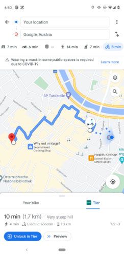
Micromobility provider TIER and Google Maps have announced that they are teaming up to expand access to multimodal mobility solutions. TIER now offers a new option when planning routes for the ‘first and last mile’ in 11 major European cities. Riders will be able to locate nearby TIER e-scooters directly from Google Maps. They will also be provided with helpful information, such as a cost estimate and anticipated arrival time.
 The service is initially available in Berlin, Hamburg, Munich, Cologne, Frankfurt, Stuttgart, Vienna, Zurich, Oslo, Stockholm and Helsinki. Other cities are to follow this year. E-scooters have become firmly established in the urban mobility mix and the demand for micromobility solutions continues to grow.
Under the tab for cycling directions, users can find the ‘Your Bike’ and ‘TIER’ buttons. By clicking on the TIER button, Google Maps shows the nearest available TIER e-scooters – as well as the walking distance and the charging status of each e-scooter. To start the ride, users are then redirected to the TIER app.
“Our mission to change mobility for good is largely about creating strong partnerships to expand everyone’s access to sustainable, easily accessible and multimodal mobility solutions,” says Tinia Mühlfenzl, director of market development at TIER. “Through our collaboration with Google, we’re creating visibility for TIER scooters within Google Maps and helping to ensure that riders have access to the form of transportation that best suits their daily mobility needs.”


