Following successful trials in 2017, the North Carolina Department of Transportation (NCDOT) is continuing to research ways to use emerging drone or unmanned aerial system (UAS) technology to make highway travel safer.
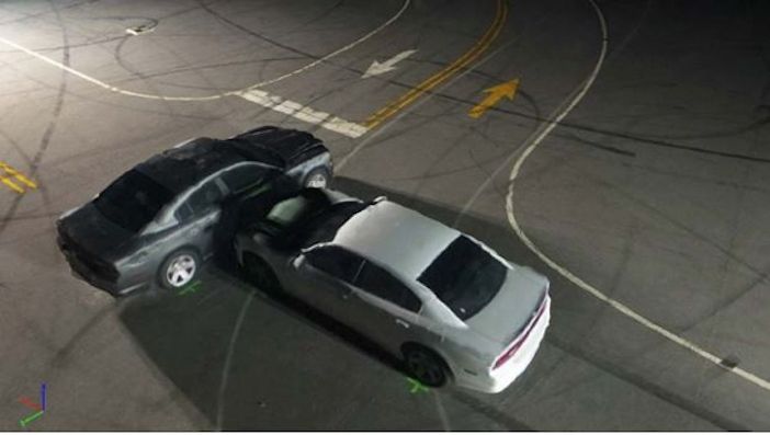
Last year, NCDOT’s Division of Aviation and the NC State Highway Patrol (NCSHP) studied the use of drones for highway collision scene reconstructions, and found that they can save money and reduce the time a roadway must be closed during a reconstruction.
NCDOT’s Photogrammetry Unit studied the feasibility of using drones to create 3D models of collision scenes and compared the results against those collected by the NCSHP’s Collision Reconstruction Unit using a traditional laser scanner.
The teams found that using drones cuts the time needed to perform an accurate reconstruction from 1 hour 51 minutes to just 25 minutes. Crews could start clearing the crash scene more than an hour earlier, meaning traffic could start moving again faster. Drones also significantly reduce the risk posed to personnel involved, provide an aerial perspective of the scene, and are cheaper and easier to use than current technologies.
To follow up, the groups involved wanted to study using drones in low-light reconstructions to see if it was possible and, if so, how much and what type of lighting would have to be brought to a scene. A new study was commissioned by NCDOT and NCSHP, with the project conducted by non-profit research institute RTI International and the University of North Carolina at Charlotte (UNC Charlotte).
Key findings from the study were:
• Drone data can provide evidence-grade images in some low-light conditions when supplemented with appropriate external lighting equipment;
• Drones can provide report-grade images that will add value to collision scene reports in most low-light conditions, even if the data is not of sufficient quality to be used as evidence in court;
• Two drones, the DJI Phantom 4 Pro and the DJI Mavic Pro, were compared and the Phantom 4 was found to be more suitable, because its larger camera sensor is sufficiently sensitive for use in low light situations, and is more stable in windy conditions;
• The quality of reconstructions in twilight conditions, when there is sufficient ambient light to view the car features and Ground Control Points, is better than for night-time conditions with artificial lights;
• The external lighting systems had the greatest impact on data quality;
• Mobile light towers are more effective than inflatable light towers for illuminating the scene, as they have a higher luminous intensity;
• Grid trajectories provide better orthomosaics; whereas, orbit trajectories provide 3-D reconstructions with better lateral feature reconstructions. Using both double grid and orbit trajectories to record combined image datasets is recommended.
“Last year’s study was groundbreaking,” said Basil Yap, manager of NCDOT’s UAS Program Office. “We found that not only does it save thousands of dollars, but using drones instead of traditional ground-based reconstruction techniques also cuts the time each reconstruction takes from almost two hours to less than half an hour.”
RTI’s lead researcher, Joe Eyerman, commented, “Provided they use the right kind of equipment, drones are capable of producing high-quality collision reconstructions in darker settings. Obviously, many collisions occur in less-than-perfect conditions, so knowing that the Highway Patrol can still use this technology is great news.”


